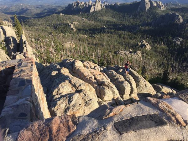
Hiking

Hiking

At 5,318 feet above sea level, Custer is a natural playground for anyone who loves to hike. You’ll find a variety of trails in the area that offer easy to strenuous climbs. Located just outside the Custer Chamber of Commerce building, you’ll find two trailheads—one that leads you to the top of the Custer sign and the other that takes you to the 109-mile Mickelson Trail.

Located inside Custer State Park, hikers will find some of the best trails in all the Black Hills. Wander along mountain lakes, through rolling prairies and up forested mountain peaks as you explore the natural beauty of western South Dakota. Trail maps can be obtained at the Peter Norbeck Visitors Center or by visiting the Custer State Park website.

Located near Sylvan Lake- featured in Disney’s “National Treasure: Book of Secrets—you’ll find one of the trailheads leading to the summit of Black Elk Peak (formerly Harney Peak), the highest point in South Dakota. The 7,242 summit is also where Lakota medicine man, Black Elk, had his powerful vision of the Battle of the Little Bighorn and the Massacre at Wounded Knee. Black Elk Peak is located in the Black Elk Wilderness of the Black Hills National Forest. Trail maps for the Black Hills National Forest can be obtained at the Visitor Center located at Pactola Reservoir or downloaded from the Forest Service website. A comprehensive list of trails can be found at the Forest Service website, as well.

Recommend Hikes Near Custer

  • Badger Clark Historic Trail (1 mile loop): Charles Badger Clark 1883 -1957) was the first poet laureate of South Dakota. This short trail winds behind his historic cabin.
  • Cathedral Spires Trail (1.5 miles one-way): This moderate to strenuous trail is a one-way hike that winds through the ponderosa pines. Along the trail you find the Cathedral Spires/Limber Pine Area that is a Registered National Natural Landmark.
  • French Creek Nature Area (12 miles one-way): French Creek is the where gold was first discovered in the Black Hills. This moderate hike takes you along the meandering creek into a granite gorge. Bighorn sheep are often seen in this area.
  • George S. Mickelson Trail (109 miles): This rails-to-trails project starts in the northern Black Hills and ends at the southern tip. Built along the historic Burlington Northern Railroad line, hikers will find gentle slopes, low grades and over 100 converted railroad bridges. There are several outfitters and trailheads located along the route. In Custer, the Mickelson Trailhead is located in Harbach Park across the Chamber of Commerce building.
  • Black Elk Peak (7,242 ft. summit): There are multiple trails that lead to the Black Elk Peak summit. The easiest is the southern approach from Sylvan Lake, which has just over a 1,000 foot elevation gain over the three and a half miles. The northern approach is longer and more difficult, but is considered by some hikers to be more scenic. This five-mile route starts at the Willow Creek Horse Camp and gains 2,200 feet in elevation before reaching the summit.
  • Little Devil’s Tower Spur Trail (1.5 miles one-way): While this hike starts off steep, it levels out as you ascend to the summit. At the top you will be able to see spectacular views of the Black Hills and the fire tower atop Black Elk Peak.
  • Lovers Leap Trail (3 mile loop): This hike is not for the faint of heart. The trail starts with a large incline through the forest and follows along a steep ridgeline. Hikers who make this strenuous climb are rewarded with views of Black Elk Peak, Cathedral Spires and Mount Coolidge.
  • Mount Rushmore to Horse Thief Lake (3 miles): This one-way trail starts at Mount Rushmore National Memorial and offers scenic views of the hills and access to other trails that lead to the summit of Black Elk Peak.
  • Prairie Trail (3 mile loop): This loop trail explores a portion of the park's rolling prairie grasslands. Native plants and grasses of this area make prime habitat for bison, pronghorn and deer. Vantage points from the flat-topped hills offer panoramic views of the vast prairie of the southern Black Hills. The Prairie Trail hosts one of the most spectacular summer wildflower displays in the area and has a few stream crossings (usually dry in late summer). Near the end, a portion of the trail follows a small stream through stands of mixed hardwoods.
  • Skywalk Trail (0.5 mile): Enjoy a pleasant walk in the woods with a million dollar view from the top of the hill. There are a lot of steps on the way, but the end of the trail is worth the effort. Starting from the trailhead at an elevation of approximately 5,300 feet, the assent to the base of Big Rock formation is 280 steps, with an elevation change of approximately 140 feet. The stair steps from base of Big Rock to the top is approximately 55 steps with an elevation change of approximately 27 feet.
  • South Dakota Centennial Trail (111 miles): Officially open in 1989 to mark the 100th anniversary of statehood, this scenic trail spans the length of the Black Hills from Bear Butte State Park in the north to Wind Cave National Park in the south. This trail is used by hikers, bikers and horseback riders. Three trailheads are located near Custer and in Custer State Park.
  • Sunday Gulch Trail (2.8 mile loop): This trail showcases the true beauty and uniqueness of Black Hills geology. Pine, spruce and birch line the trail that crosses a babbling brook and alongside a solid granite wall.
  • Sylvan Lake Shore Trail (1 mile loop): This nearly-flat trail is an easy walk that takes you around the crown jewel of Custer State Park—Sylvan Lake. This unique mountain lake is surrounded by rounded-granite outcroppings and towering ponderosa pines.

Things to Remember When Hiking

  • Elevation changes can mean changes in the weather. Be sure to dress in layers and have hats, sunglasses and sunscreen along. Afternoon thunderstorms are very common in the summer.
  • Hikes vary in length and difficulty. Know your limits and be sure to bring plenty of water and wear sturdy shoes.
  • For your own safety, leave a message with someone about the trails you will be hiking and your estimated time of return.
  • Pack out what you pack in. Please help us keep the Black Hills beautiful so others may also enjoy them.
  • Be a responsible hiker by staying on designated trails and roads. Remember Tread Lightly.
  • Do not feed the wildlife and maintain a safe distance.  Mountain lions do live in the Black Hills, and while encounters are rare, be prepared in case you come across one.  Remember- DO NOT RUN. Instead maintain eye contact with the lion and become aggressive by throwing objects or waving sticks. Make loud noises by yelling and do what you can to appear as large as possible. For more information read the Game, Fish and Park brochure “Yes, Mountain Lions Live in South Dakota.” You can find this publication at the park office located along the Wildlife Loop in Custer State Park or any other SD GF&P office in the Black Hills


615 Washington Street
Custer, SD 57730
605-673-2244
800-992-9818
Info@CusterSD.com


Hours:

M-F  8am-5pm
Sat   Closed
Sun  Closed


           Member of

Copyright © 2024 CusterSD.com All rights reserved | Privacy Policy